

TopoFlight – 3D flight planning and navigation
TopoFlight is a 3d flight planning software which allows the fast and interactive design of flight plans. The inclusion of digital elevation models leads to best results and minimizes the amount of images and thereby the costs of any flight mission. Different export interfaces allow an easy transfer to almost any flight management system. TopoFlight can be used to plan photogrammetry and LIDAR missions and supports frame, line and LIDAR sensors. TopoFlight presents the results as maps and tables and can be used for calculating the project costs what simplifies the quotation generation explicitly.
Products
Mission Planner -3D flight planning software
TopoFlight Mission Planner is a 3d flight planning software which allows the fast and interactive design of flight plans. The inclusion of digital elevation models leads to best results and minimizes the amount of images and thereby the costs of any flight mission. Different export interfaces allow an easy transfer to almost any flight management system. TopoFlight Mission Planner can be used to plan photogrammetry and LIDAR missions and supports frame, line and LIDAR sensors. TopoFlight Mission Planner presents the results as maps and tables and can be used for calculating the project costs what simplifies the quotation generation explicitly.
TopoFlight Mission Planner can be fully tested over a period of 10 days! Download the software and ask for a demo license.
Many small to large projects worldwide are being carried out with the help of TopoFlight.
Highlights of TopoFlight Mission Planner (automatic editing)
Highlights of TopoFlight Mission Planner (manual editing)
Navigator – Flight Management System
TopoFlight Navigator is used to navigate the airplane or helicopter for image and LiDAR data acquisition. A predefined flight plan (e.g. provided using TopoFlight Mission Planner) is used as base data. The camera is triggered at the pre-defined positions.
With the introduction of version 10 of TopoFlight Mission Planner, it is possible to plan flight lines along the terrain. This means: flight lines are still straight lines but they follow the terrain up and down. This is very useful for helicopter flights. With TopoFlight Navigator such flight lines with changing altitudes and constant height above ground can be navigated.
Flying with TopoFlight Navigator
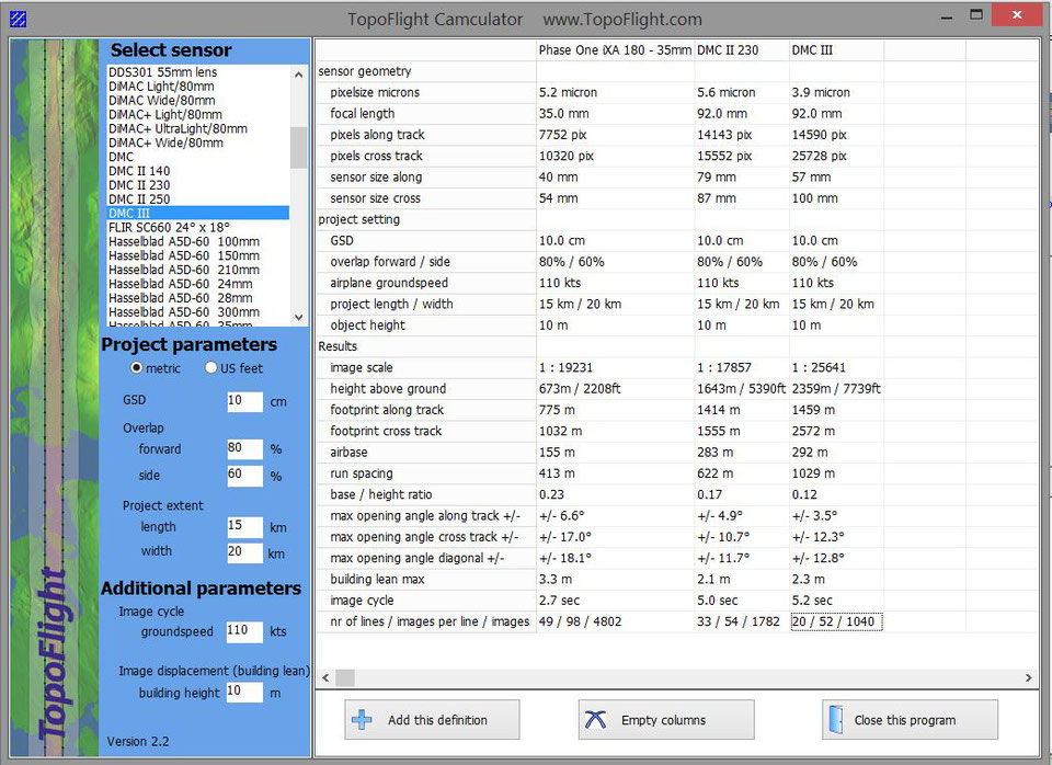
Camculator – Compare cameras
TopoFlight Camculator is a free tool to efficiently compare different cameras against each other. In today’s market, there are many sensors available. Our software shows the characteristics of each sensor for a project with selectable parameters (like project extent and GSD).
User interface of TopoFlight Camculator:
Software Sources Ltd. is serving as TopoFlight Reseller.